INTRODUCTION
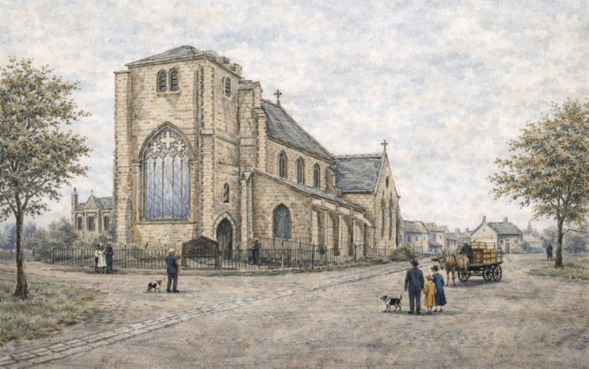
In April 1985, the then Archaeological Survey of Merseyside was advised by St Helens Metropolitan Borough Council of a planning proposal to re-route a sewer pipe in Newton-le-Willows. The work was to involve the construction of a manhole within the ruins of the water-mill (NGR SJ 5927 9528) which stands on the west bank of Newton Brook, southeast of Newton-le-Willows church and west of Mill Lane (Figure 12).
The existing mill remains appeared to date from the 18th century, but documentary evidence suggested that there had been a mill on or near this site since at least the mid-17th century and possibly earlier. As the proposed manhole was to require the sinking of piles down to bedrock and would involve considerable disturbance of the archaeological layers in this part of the mill, it was felt that the opportunity should be taken to open a small trench to examine the archaeological stratigraphy in advance of the construction work.
During July and August 1985, the existing remains were surveyed under the direction of R.A. Philpott, and a small trench approximately 2.0m x 2.3m was excavated by hand by the writer with the assistance of R. Lawrence in the southeast corner of the mill.
Documentary evidence
The earliest references to mills in Newton-le-Willows appear in the Pipe Rolls for the years 1200-4, which indicate that at least two were in operation by that time (Farrer 1902, 131). The mills were held along with the manor by the Banastre family, who also had the fee of Makerfield and the Barony of Newton. In 1554, Sir Thomas Langton, who had inherited the fee of Makerfield and the barony, sold property including two mills to Sir John Byron and others (Farrer 1910, 107).
Until 1653 there is no indication of the location of the mills, but in that year Newton Hall and mill, then the property of Sir Richard Fleetwood, were broken into and damaged (Stanning 1891, 328). The source implies that the hall and mill were in close proximity, and given that the later mill stands only fifty metres from the site of the hall, it is probable that the 17th-century mill stood on, or close to, the same site.
In 1660, ‘Newton Milne’ and Dam, together with the Manor House and chief rents, were sold by Thomas Fleetwood to Richard Legh and subsequently formed part of the Legh Estates (JRL AA 13). Dr. Kuerden, a local antiquary, in his tour of Winwick parish in c. 1695 records seeing a water mill on the left-hand side after crossing the little stone bridge over Newton Brook (Farrer et al. 1911, 123), and this is almost certainly the predecessor of the present brick mill.
In 1771, the mill was burnt down and rebuilt. The Articles of Agreement for the rebuilding state that it was a brick building roofed with slate, but the dimensions were not entered in the document (JRL XA/XB). The same agreement required four pairs of millstones, one pair of ‘French Bun Stones’ and two more pairs of grey stones. It was intended to use the mill not only for corn but also oats and malt.
The evidence of maps and engravings
Newton Mill, with the dam and millpond, is shown on Benjamin Yoxall’s 1745 estate map of Newton (Figure 13). A rental of 1750 records that ‘the several alterations made at Newton Mills cost at least £250’ (JRL PA 4). Although some work may have been carried out either downstream at Red Bank Mill or Dene Mill north of the town, which both appear to have been in use at that time, the major part of this work may have taken place at Newton Mill. This may account for the differences in ground plan evident on an undated but probably later 18th-century plan of Newton (LRO DDX 153/5/2), (Figure 14), which are followed by the later Legh Estate map of 1827 (MRO 296) and the Tithe Award map of 1839 (LRO DRL 1156) (Figure 15).
The variations in plan of the building after 1745 may be in part due to the difference in scale between the maps; nevertheless, the plan of the building appears to have altered considerably between the 1745 map and the later 18th-century plan, resulting in a change in axis. The date of the latter plan is uncertain, but the variations in the plan of the mill suggest it post-dates the rebuilding of 1771. Between the drawing of the late 18th-century map and the 1827 and 1839 maps, the mill becomes squarer with an extension to the southeast, which can be seen on engravings of the period. The excavation and documents support the map evidence that alterations were made to the mill in the intervening period.
Engravings provide some evidence for the appearance of the mill in the early 19th century. An undated lithograph by W. Smoult of the railway bridge over Newton Brook, which probably dates to the 1830s, soon after the opening of the railway, shows the mill as a tall, narrow, three-storey building with a lower extension to the south (Figure 16). The general plan of the building accords well with the evidence from the tithe map, but the masonry construction may be artistic license rather than accurate draughtsmanship. Another engraving of c. 1833 shows the mill as a four-storey structure with a two-storey extension to the southeast and a large opening, apparently in the eastern side, through which part of the mill machinery is visible. The precise details, however, are open to question in view of the curious perspective which places Newton Hall between the mill and the railway bridge.
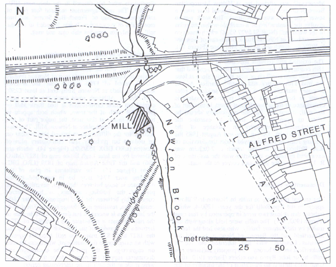
Figure 12: Location of Newton Mill, Newton-le-Willows
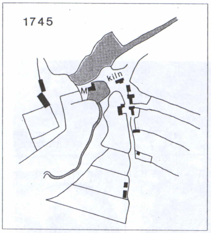
Figure 13: Newton Mill on the 1745 Legh Estate map by Benjamin Yoxall (St Helens Library).
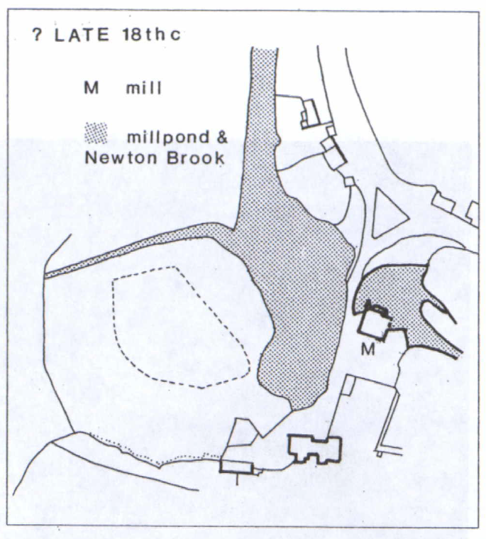
Figure 14: Late 18th-century plan of Newton (LRO DDX 1531512).
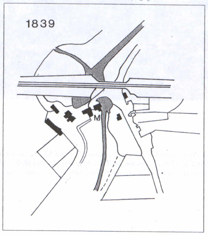
Figure 15: Detail of Tithe map for Newton, dated 1839 (LRO DRL 1156).
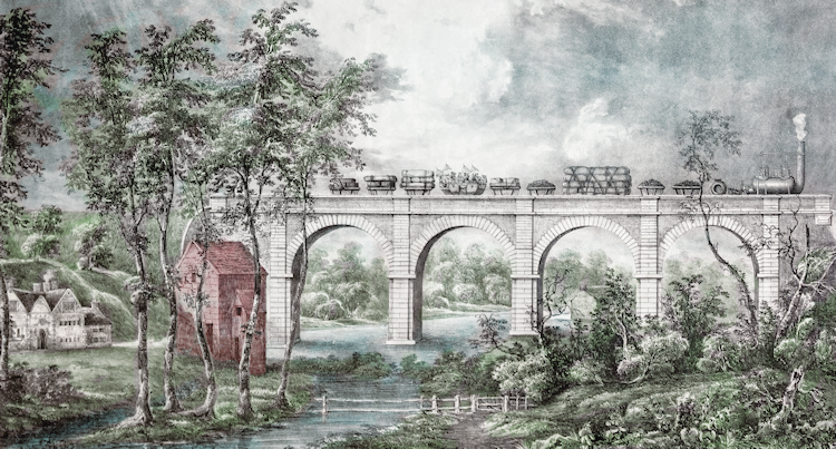
Figure 16: Detail of ‘Viaduct at Newton on the Line of the Liverpool and Manchester Railway’. Drawn by W. Smoult, HG. James lithographer, undated (c. 1830s). Newton Mill lies between Newton Hall to the left and the railway bridge to the right. Reproduced with permission from Liverpool Record Office, Liverpool Libraries and Information Service.
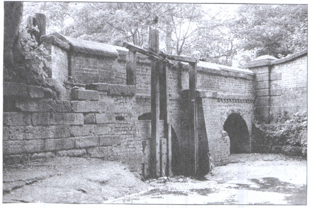
Figure 17: View of the sluice gear and bridge, from the northeast in 1985.
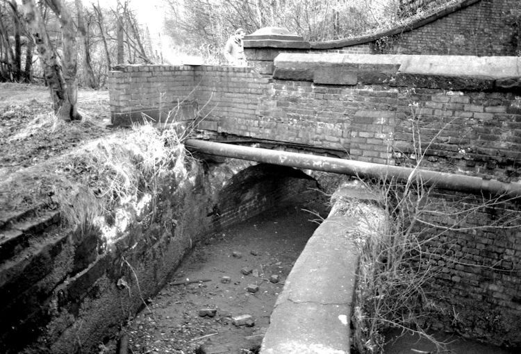
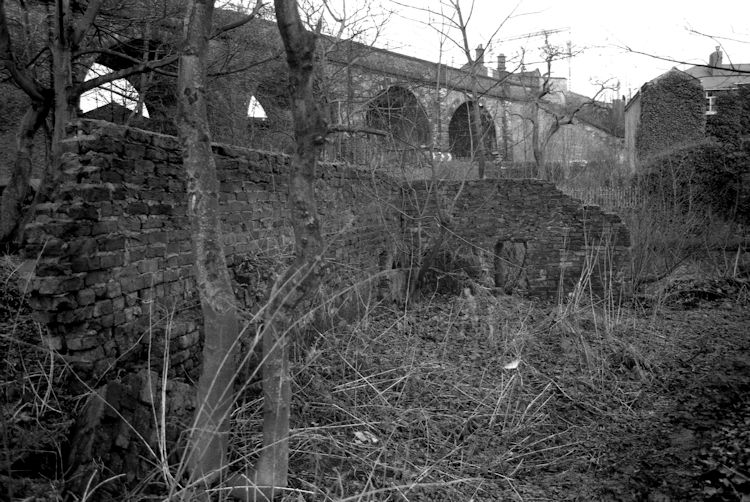
Figure 18: View of Newton Mill in 1985 from the north, showing the head race and recently rebuilt mill walls.
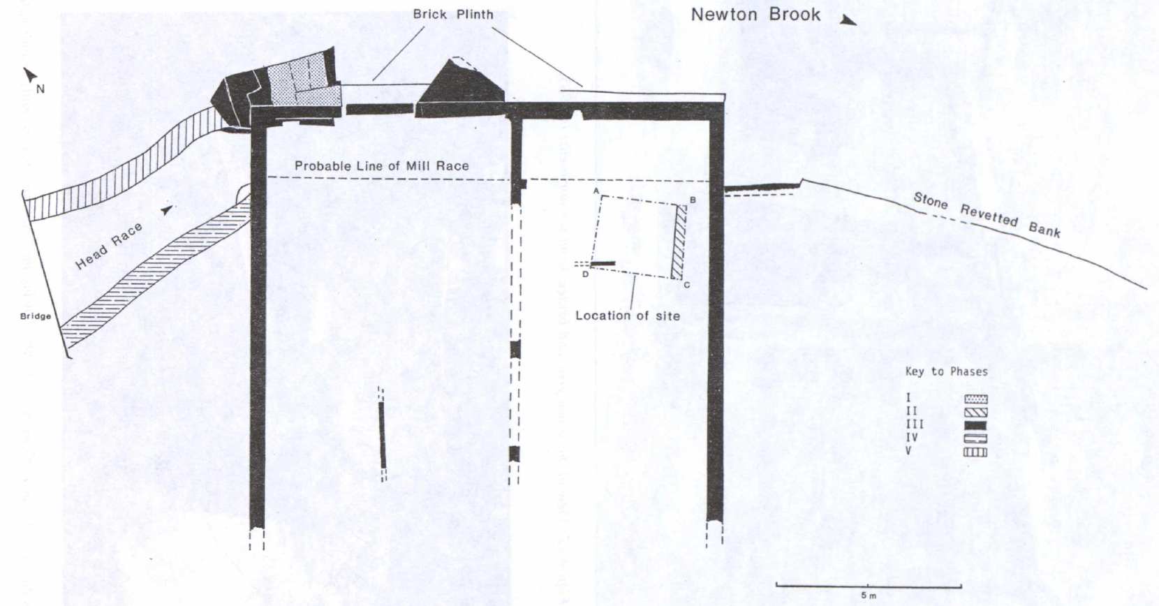
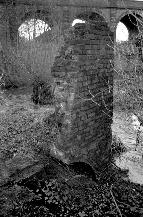
Figure 19: Newton Mill: the 1985 survey showing the location of the excavated trench. Newton Mill remained in operation until August 1906 when a disastrous fire caused extensive damage and the walls were taken down to within a few feet of the ground and never rebuilt (Lane 1914, 51). The ruins of this structure are still visible but the ravages of weather, vegetation, and vandalism have taken their toll in recent years (Figures 17 and 18).
THE EXCAVATIONS
A single trench was opened measuring approximately 2.0m x 2.3m close to the southeastern corner of the mill within the surviving ruined structure (Figure 19). The presence of a deep deposit of loose sand in the sides of the trench and vandalism during excavation resulted in sloping rather than true vertical sections. The following structural sequence was observed from the excavation (Figures 20-23). The phases correspond to those identified from a combination of excavation and structural survey.
Phase I a: Water-borne silt deposit (earlier 18th century)
The earliest deposit encountered on the site consisted of a shallow layer of fine silt (33) lying directly on the Perrno-Triassic sandstone. Finds within the silt suggested a date of the earlier 18th century for the deposition of the layer.
Phase I b: Post-hole construction and disuse (mid 18th century)
A post-hole (36) had been cut through the base of the primary silt layer (33) into the underlying sandstone bedrock, although the similarity of the upper fill of the post-hole and the surrounding silt meant that the cut was only visible at the bottom of the deposit. Where it cut the sandstone bedrock the post-hole was square in section with sides measuring approximately 0.20m. The fill of the post-hole consisted of a reddish-brown mixed sandy fill with sandstone and brick debris (35), with a dark brown silty sand deposit below (37).
Phase I c: Demolition layer
Above the primary silt, and also sealing the post-hole, was a deposit of crushed sandstone (32), which increased in thickness towards the east. The removal of the post from the post-hole had created a hollow into which subsequent layers had collected, including (32), a layer of sandstone brash, which probably represents the demolition of a structure in the vicinity. The hollow remained open long enough for three further layers, (30), (29), and (23), to collect in it (see below). The nature of the lower two of these layers, which probably formed fairly rapidly under water, need not imply a long interval between the removal of the post and subsequent construction work on the site.
Phase II a: Alteration of brick mill on stone foundation (1750)
At the southern end of the trench, a shallow slot had been cut into the silt into which the sandstone foundations of a wall (16) had been inserted. The wall survived to a height of two courses to the west, while to the east an additional course had been necessary due to the uneven nature of the bedrock surface. The sandstone foundations supported a brick superstructure which had left traces in the surface of the mortar on the sandstone foundation.
Immediately over the alluvial silt layer (31) was a thin deposit of black organic material (30), probably formed in slow-moving or stagnant water, which had been covered by a shallow silt deposit (29). This in turn was overlain by a spread of trampled mortar (23), which although not extending as far as the foundation (16), was presumably derived from the construction of the lower part of this wall. Above the mortar were two distinct, but probably closely contemporary, deposits of sandstone brash with many irregular blocks of sandstone and a few bricks (18), which had been dumped against the base of the wall to level up a flat surface. Overlying the dumped sandstone and butting against the sandstone lower wall (16) was another thin deposit of mortar (14), probably from the construction of the upper part of the brick superstructure above the sandstone foundation (16).
Phase II b: Destruction of the brick mill on stone foundation
In the next phase, the wall (16) had been demolished down to the foundations and the wall materials mostly removed, except for some bricks left on the existing surface of the sandstone brash.
Phase III a: Construction of the brick mill (c.1771)
The whole area was then covered with a deep deposit of clean yellow sand (5). Into this had been cut the construction trench (7) for the southeastern wall of the later mill, which had been partly backfilled with mortar (8). Several sandstone flags about 40 mm thick (2) from the floor of the later mill remained in situ around the edge of the trench. In places, they had been bedded on a deposit of orange silty clay (3). A wall, one brick in width (19), rested on a shallow soil deposit over the sand layer (5) and formed an internal partition wall for the later brick mill.
Phase VII: Destruction of the brick mill (early 20th century)
Subsequently, most of the floor flags had been removed and although disturbance of the upper stratigraphy made the precise relationship unclear, a number of pits (41), (44), (46), (48), (49), had been cut into the sand (5), probably in the 20th century. The fill (47) of pit (46) included many roof slates and lumps of solidified tar, which may have come from the destruction of the mill by fire in 1906. The finds within contexts (11) and (12) indicate a 20th-century date for their infilling.
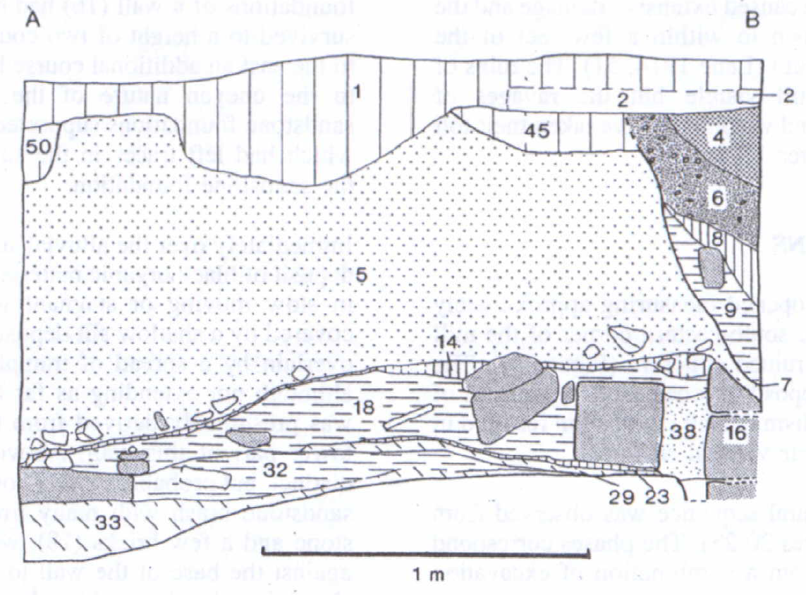
Figure 20: The 1985 excavation: section A-B
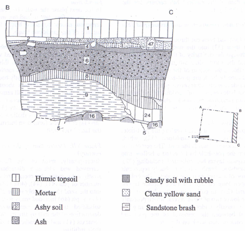
Figure 21: The 1985 excavation: section B-C
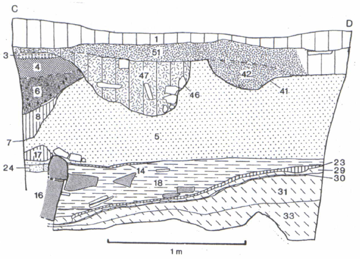
Figure 22: The 1985 excavation: section C-D
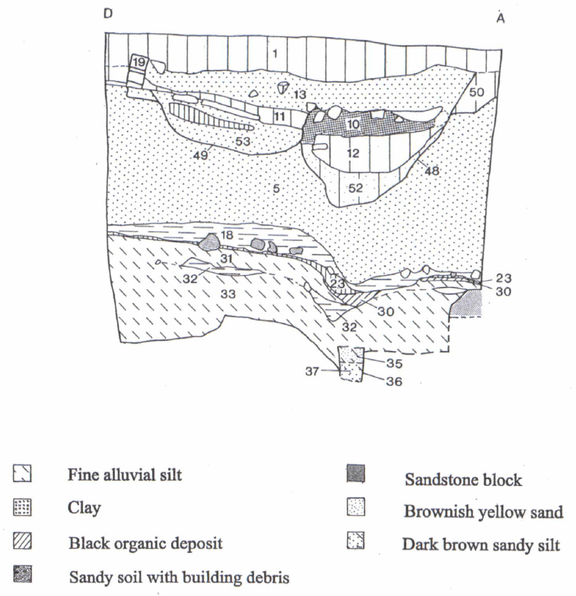
Figure 23: The 1985 excavation: section D-A
Interpretation and dating
The earlier layer on the site, the alluvial silt (33), which was overlain by the base of wall (16), contained a few pottery sherds and two clay tobacco pipe bowls, one dated to c. 1710-30, the other to 1730-50 (P.J. Davey per comm.). This area was therefore periodically at least under water until the mid-18th century, and supports a date of after c. 1730-50 for the construction of the overlying wall.
The dating of the phases of the mill construction hinges largely on the identification of wall (16) with the 1750 ‘alterations’ and the documentary reference to the rebuilding of the mill in 1771. Although no finds were recovered from the construction slot, an abraded sherd of slipware of late 17th- or early 18th-century date found in the interstices of wall (16) provides a terminus post quem for its construction.
The absence of datable 19th-century finds from layer (5) which sealed the sandstone wall (16) and from the construction trench (7) for the latest mill suggests a date no later than 1800 for the brick mill. The documentary evidence for alterations to the mill in 1750, which in view of the great cost are likely to have been major in scope, provides a plausible historical context for the construction of the wall. In addition, comparison with other buildings in Merseyside suggests that the technique of a brick superstructure on a sandstone plinth is consistent with an 18th-century context. This suggests that the “alterations” required partial demolition of the existing structure and the erection of a wall (16), possibly as an extension to one side of the mill structure, since it was constructed on an area which was under water until the mid-18th century.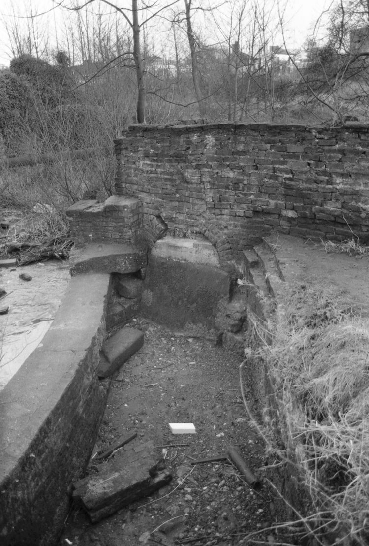
Although the post-hole (36) had cut the lowest part of the alluvial silt deposit (33) which contained datable clay pipes (see above), the silt layer may have developed over a considerable period of time and the finds do not therefore provide a close date for the cutting of the post-hole. The layer of sandstone brash (32) partially sealed the earliest silt layer (33), which had a terminus post quem of 1730-50 (see above), and thus the sandstone (32) may represent the demolition of part of the sandstone mill in preparation for the 1750 alterations. Two joining sherds of black-glazed pottery found in the fill of the post-hole (37) appear to be of mid-late 18th-century date.
The pottery found in layers sealed by the sand levelling deposit (5), in the sand itself and in the construction trench for the later brick mill (6), (8), (9), need not be later than the mid-late 18th-century, and a firmer terminus post quem for the rebuilding of the mill in brick is provided by a sherd of creamware, of late 18th-century date, found sealed under the sand layer (5), in a pocket of sand (38) trapped between the base of wall (16) and a large sandstone block. This, together with the absence of 19th-century China or other wares, suggests the rebuilding of the mill took place in the period 1765-1800. The discovery of the document referred to above, which records the 1771 rebuilding of the brick mill, provides a precise date for this episode.
SURVEY OF STANDING REMAINS
In addition to the excavation, a survey of the remains of the mill building and mill-race was undertaken (Figure 19). This involved a measured drawing of all the visible remains, and although some clearance of surface vegetation was necessary, no excavation was undertaken to reveal buried remains.
The mill structure
Although superficially the mill appears to be entirely brick-built, closer examination revealed substantial portions of earlier stonework incorporated into the fabric. The earlier sandstone masonry survives along the northeastern wall of the brick mill and follows a slightly different alignment, projecting further into the brook at the north end, where a curved portion of stone walling has been retained and the later brick mill set back behind this. The stone projection on the northern corner was almost completely encased in brick and converted into a flight of steps in brick and stone, of which four stone steps remain. A massive brick pier roughly triangular in shape and projecting into the brook was added halfway along the northeastern wall of the brick mill, perhaps to provide additional support for the axle of the mill-wheel.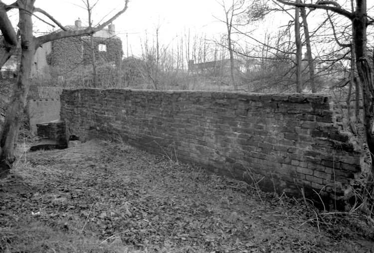
The northeastern wall has a brick plinth at the base, which survives for almost its whole length, with a width of approximately 1 metre from the steps to the spur and 0.5m from the spur to the eastern corner. The southeastern and northwestern walls, together with the visible internal partition wall, are of the same brick phase. The southwestern wall was not visible and therefore could not be surveyed.
The mill-race
The structure of the mill-race can be divided into three elements:
- The head-race, bridge, and sluice
Abutting, and therefore later than, the northwest wall of the mill, at the northern corner, are the walls of the head-race. The head-race walls appear to have two distinct phases. The structural remains of the earlier phase consist of most of a southern wall of sandstone blocks, and a northern wall, of which only a short stretch of a single sandstone course survives above ground. This latter was incorporated into a later brick wall, built on a different alignment which created a much narrower channel. In the later phase, the southern wall of the head-race was retained largely intact, and was subsequently patched with brickwork.
The surviving remains allow for two interpretations. If the short course is seen as surviving almost unchanged, then the earlier phase of the head-race can be reconstructed as having a ‘spur’ to break the force of the water and divide the flow, possibly the triangular feature shown on the later 18th-century plan (Figure 14). If it is seen as the remains of a longer wall, it may have taken the form of a channel that narrowed immediately before the first arch of the mill-race, and such a feature is shown on the later 18th-century map. The velocity and therefore the efficiency of the body of water was probably controlled by a small sluice-gate at this arch, although the only hope of proving this is by excavation.
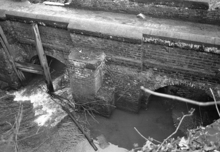
The bridge and sluice-gate beyond the head-race belong to a later phase than the head-race itself. The existing bridge is built of brick, with two arches, and abuts the second-phase brick wall of the head-race. On the other side, it abuts the foundation wall of the railway embankment which was constructed in the late 1820s, providing a terminus post quem for the construction of the bridge. Although the whole of Newton Brook now flows under the eastern arch, in this second phase the volume of water passing through could be controlled by means of a sluice-gate (Figure 17), part of the surviving mechanism of which was destroyed by vandals in 1985.
- The race within the mill
The central portion of the mill-race ran under the mill-house and provided the power to turn the wheel, which would have been mounted inside the mill-house. The arched openings of the mill-race are visible but blocked and the race is now inaccessible.
- The tail-race
At the point where the race would have left the mill adjacent to the west bank of the brook, the bank has been revetted with a north-south wall which extends beyond the area surveyed and abuts the southeastern wall of the mill building. The revetment wall seems to consist of two phases, one of stone and a later one of brick, built partly on top of it. This wall may have formed part of the extension to the brick mill as shown on 19th-century engravings and plans. Alternatively, it may be no more than a stone revetment for the riverbank as seen elsewhere along the brook.
Other features noted during the structural survey include part of a possible earlier stone bridge on the northern side of the brick bridge, where there appear not only to be two builds involved but also some stone was either retained or reused as the base of the middle pier of the Phase VI bridge. Adjacent to the southern side of the bridge there survives part of a stone wall which may represent a stone revetment wall surrounding the mill-pond.
DATING OF STANDING STRUCTURES
The dating evidence from the excavation indicates that the early sandstone wall (16) was associated with the ‘alterations’ of 1750 and the standing brick structure, which amounted to a major rebuild, dates from 1771 (see above).
The plans of the area on the late 18th-century, 1827, and 1839 maps, although on a very small scale and therefore not necessarily accurate, may perhaps give some indication of date for the various elements of the building. The later 18th-century map shows the head-race with the triangular spur attached to the corner of the mill-house and these also appear on the Tithe map. However, the existing relationship of bridge, railway embankment, and head-race appears to bear no resemblance to that on the 1839 Tithe map, suggesting that both the brick bridge and later phase of the head-race date to after 1839.
The alignment of the stone wall uncovered in the 1985 excavations shows that the plan of the stone mill was not entirely coterminous with the brick mill constructed in 1771. The excavation and structural survey together revealed six phases of construction within the mill (see summary below).
THE FINDS
Finds were poor in both quality and quantity and do not merit a separate discussion. Where relevant to the dating and phasing of the site the pottery has been referred to in the text. A very worn and pierced threepence of Elizabeth I dated to the 1570s was found in the sandstone levelling layer (18), where it had presumably been lost by a workman.
PHASING OF THE MILL (RL)
I – Stone mill – Probably the structure seen by Kuerden c. 1695
II – Stone/brick mill – Alterations, in brick on a stone plinth, probably 1750
III – Brick mill – Built 1771 with head-race and triangular spur
IV – Brick mill – Construction of southern sandstone wall of head-race, butting brick mill
V – Brick mill – Head-race altered possibly after 1839
VI – Brick bridge – Butts onto railway embankment revetment wall (of c.1827), and built after 1839, a different arrangement from the tithe map
VII – Mill demolition – Brick mill largely demolished after fire of 1906
CONCLUSIONS
A combination of documentary and map evidence, archaeological excavation, and physical survey has contributed to the interpretation and dating of the remains of the mill. The physical survey showed that masonry from an earlier structure had been incorporated in the later mill, and the archaeological evidence together with the nature of the remains suggested a 17th-century or earlier date for the construction of the earlier mill.
Documentary evidence indicated that the mill had been altered in 1750, and it seems likely that the wall revealed in the excavation (16) was part of an extension to the southern part of the mill dating from this period. The discovery of fragments of clay pipes in the alluvial silt (33) indicates that the area was still open and probably part of the stream bed by c. 1730-50, and it appears more likely that the wall represents an extension to the existing structure than a complete rebuild.
Examination of the finds indicated that the date of the existing brick mill must therefore lie somewhere after the alterations of 1750 and no earlier than the 1760s. Documentary evidence subsequently confirmed the precise date as 1771. At a later date, probably during the 19th century, various alterations were made to the head-race and bridge.
Acknowledgements
We are indebted to Mr Alderman, the site-owner, for permission to excavate; to the staff of Professional and Technical Services, St Helens Borough for details of the sewerage scheme; and to Ann Duffy of the North West Archaeological Trust Manpower Services Commission team, based at the University of Liverpool (1987-88) for bringing to our attention the Articles of Agreement concerning the 1771 rebuilding in the John Rylands Library, Manchester.
The site has the Merseyside Sites and Monuments Record File Reference no 5995-05. In January 1999, the finds and archive were held in Liverpool Museum, pending agreement over their final deposition.
References
- Farrer W. 1902 The Lancashire Pipe Rolls and Early Lancashire Charters Liverpool.
- Farrer W. 1910 ‘Lancashire Final Concords. Part IV. 1510-1558’ Record Soc Lancashire and Cheshire 60.
- Farrer W., Brownbill J., and Young H.S. 1911. ‘A History of Lancashire, 4’, The Victoria County History of the Counties of England London.
- Lane J.H. 1914 Newton in Makerfield: its history and some account of its people. 2 vols. (reprint 1980, Aquarius, Warrington).
- Stanning J.H. 1891 ‘Royalist Composition Papers relating to Lancashire, Vol. II C to F.’ Record Soc Lancashire and Cheshire 24.
Abbreviations
- JRL – John Rylands Library, Manchester
- MRO – Merseyside County Record Office, Liverpool
- LRO – Lancashire County Record Office, Preston
This 1985 Excavation and Survey report was written by Robert Philpott and Rowena Lawrence