Transcribed with the help of Andrew Fackey from documents in Chester Archives
The information has been taken from Royal Lancaster Forests. Leghs of Lyme by Lady Newton. Annals of Warrington by Beaumont. Copies of charters from Warrington Museum. Information of the Parish from books kept by the Vicars, now in Preston Records Office.
Royal Forests of Lancashire.
1102-1116. Whilst the honour was in the King’s hands Burtonwood, a dependent manor of Warrington was taken into the Forest even as late as the mid 14th century. The Dukes of Lancaster still claimed Burtonwood as part of the Royal Forests. Even the Botillers were amongst those indicted for offences against venison. The true hunting territory was restricted from quite early times which included Burtonwood.
1190-1290. Grants of pannage only occurs in belts of woodland, as pig-keeping applied to Vills some distance from Sea Coast.
1225. Item except Burtoneswood (spelt like this at the time) by these bounds to wit from harvestry West as far as Sankey Brook East and from Ravneness Leach South into Bradley Brook North so that William Botiller and his heirs have common pasture and store cattle and mast for swine and timber for their Castle of Warrington and for building and for burning.
1280. Gernet family relinguishs Master of Forestship of said Forests and Woods of Burtonwood. 1334. The whole of Burtonwood thus carried the Eastern boundry of the Forest as far as West side of Warrington, including within the Forest of Bewsey, then ran North West between Parish of Winwick and Burtonwood and between Newton-in-Makerfield and Burtonwood until it met the Township of Parr.
1253. John Diconson of Burtonwood took a Soare Stag by Manor of Bewsey along with Sir William le Botiller and William le Dallum of Warrington. There were cases of Oaks being taken.
Bold Charter.
1254. Grant by William Ferrers Earl of Derby to William Bold. Beginning at the Hardsty on Burtonwood being the boundry of Burtonwood and so to the Hayleyhed in Burtonwood.
Botiller Charters.
1269. First time Burtonwood mentioned.
1280. Sir William Botiller and his heirs grant for piece of land in his wood of Burton called Harderslegh.
1307. Grant to Robert Tait and Avice his wife 1½ acres of land in Burtonwood.
1308. William Botiller leaves Richard, once the groom of William le Porter, 60 acres in Burtonwood lying at Hardeslegh.
1314. William Muskell and Amcota his wife granted land and waste in Burtonwood near the waste of Eggardeslegh.
1318. Burtonwood again in a Charter granting grazing for 3 oxen and a horse working on land in the Forest of Burtonwood except at mast time.
1323. Grant to John Parker and Joan his wife 30 acres of waste in Burtonwood lying between Moss le Woods and Markells Moss and right of way for cattle in and out housebot and haybot on the wood of Burtonwood.
1324. Grant to Richard del Rever and wife Marriott 77 acres in Burtonwood with court yards and buildings thereon with old wood for burning with view of Forester and common pasture for 2 farm horses, 4 plough hordes except when waste falls.
1324. Grant to Allan the Ward of Sutton 10 acres of land and waste lying in Hayleghead, 10 oxen, 12 sheep except in mast time and with housebot and graybot for burning in view of the foresters grinding corn at the Lords mills. Mentions lands at Hayleyhead, one abutting on Deep Leach and the other on le Hordes waste.
(This could be brook on lane to Haley Head running behind schools and side of Bridge Inn. Hardeshaete could be area called School Brow Elm Tree Inn.)
1332. William Muskil of Burtonwood and all his waste and woods within Burton¬wood to he and his wife Amcota with Common Wood of Burtonwood not enclosed with pasture for oxen and two horses, eight sheep except at mast time and quitannce of pannages for 23 swine.
1349. Free tierbury in the Moss of Markelemoss and free fishing in the water of Sankey when the above bounds hold. Mills of Burtonwood and also old park of Bewsey back of waters of Sankey.
1349. William grants to Norman Botiller his son in Burtonwood called Moswood. Beginning at the corner of Penkford following middle of water of Sankey to bounds of Vil of Parr along the bounds to boundry of the Quetalegh with out lanes of Burtonwood common of pasture not enclosed and free tierbury on the Moss of Marlalmoss and free fishing in the Sankey.
1406. Charter to make a weir in Sankey Water. Parson of Winwick (fish abounded in Dullam Brook)
1407. Charter with Ralph de Standish in the Water of Sankey between the houses called Water Houses and a road called The Causeway.
1542. Dullam Meadow mentioned.
1543. Mentioned 30 acres of wood, 300 acres of Gorse and Heather in Burton¬wood and Great Sankey.
Legh Charter.
1495. That Alison widow of John Williamson says she and her husband dwelt at a place in Burtonwood by the side of Bradley.
100 years or so ago.
Prior to the Mines at Collins Green and Bold being worked, Burtonwood had very few houses. On borders of Parr and Broad Lane – possibly 4 cottages.
The Railway between Liverpool and Manchester had no bridges – only level crossings.
Station Master’s house (Mr. Dawson) for Collins Green, the Coal Siding called Rimners Yard.
Possibly 12 cottages in Collins Green.
Along Lumber Lane cottage for the Smithy (Pierpoint) and 12 corner of Green Lane, (Critchley).
At foot of Forshaws Lane was old cottage – still there today called Robin Hood and Little Jack.
The Botillers had land in Nottingham and the Woods in Burtonwood were the attraction.
School Brow – Burtonwood Old School House and Schools,
Barrows Post Office and Travers Cottage,
Old step house by Wesleyan Chapel, and behind these the Irish Row.
One of the step houses was a Pub and I believe cloth was made in Hindley’s Row years ago.
Old house at foot of Chapel Lane and Fir Tree Lane.
Green Jones Brow several cottages. Also several down Alder Lane.
1860. This must have been when Coal Mines started with main line along side of Bold and Collins Green Collieries.
Industries – Copper Works and Industry started in St. Helens.
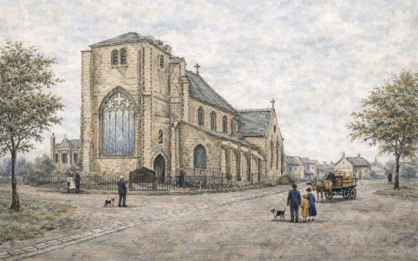
The houses were built to accommodate the miners both in Burtonwood and Collins Green. A well was sunk to supply Burtonwood houses. The same men Muther & Gaffney also sunk the 100 foot well at the Brewery. Strangely the well water was suitable but Collins Green Water was a hard water. All the artisan wells sunk by the Brewery have proved good brewing water. All this Industry spoilt the fishing in Sankey Brook or River Sankey. A Farm behind the Fiddle Inn, when the Mersey at full tide the water rose in the Sankey Brook and the cellar of the Farm at high tide, fish were caught and then cellar grill closed. Old timers said the farmer took a cart load of fish to Warrington. There were many ponds in the fields of Haley Head and Yew Tree as farmers took out the marl for fertilizing the land. Alice Kilshaw who lived at Fields Farm said the crops were badly affected by the fumes from St. Helens Industries, destroying many trees on the Farms and wild flowers. Thomas Kilshaw lost a lot of money trying to stop the damage to his crops by litigation – the damage eventually ceased. No doubt the Brooks (one from Bold Colliery) through White House and Yew Tree Farm, eventually join the Brook at Bridge Inn and the Brook coming from Gorsey Lane. This brook at foot of Tan House Lane eventually joins Sankey Brook. No doubt fishes from the River Sankey come up to these Brooks and streams. Alice Kilshaw said in Spring time lanes were full of Primroses, Blue Bells and Gorse Bushes. Fields on Bradley and Boarden Barn and down Alder Lane have many trees. She also said where now Bold Waste Heap (Stuff Rook) was a wood shown on Survey Sheet with Railway 1849. Most of the Farms must have had springs before town’s water from Warrington connected. Yew Tree Farm had a water pump at back door. In the 1849 Survey Sheet the cottage foot of Forshaws. Lane named Robin Hood and Little Jack. 1895. George Anders founded the Dahlia Queen. Mrs. Wilson, widow of the Rev. Wm. Wilson was present at the Crowning. She was the widow of James Forshaw and married the then Vicar Rev. Wilson in 1890. He died the following year.
1921. Recreation Ground in Burtonwood was presented to the Parish.
1930. The owners of Haley Head and Yew Tree also of Wheatsheaf and Bushells Farm on Bold boundary proceeded to plant an avenue of trees in following years down Back Lane and what was previously post and wire fencing planted a double hedge and spinnys of trees on Haley Head fields, also planted trees along Green Lane and Broad Lane with hedges, also on parts of Higher Farm.
1936. During the Rev. Mitchell’s time, as Rural Councellor, he was anxious to have houses built between the two villages. After his passing the new Rural Councillor had all the farms mentioned made into a Green Belt and sold four acres in Gorsey Lane to the Rural Council for houses which was the beginning of the new Village. The Fir Tree Farm was purchased by the Rural Councillor and he had submitted plans to build houses in Fir Tree Lane but the Farm was sold to Burtonwood Engineering Company and later sold by them to present owners who sold land not required for Engineering to house building company. Burtonwood situated 3 miles from Winwick Main Road to London and the North. This is one reason the Botillers chose Bewsey with Woods and Sankey River running by, also water to grind the corn in the mills and the same applies to the Leghs of Bradley and the Bolds on Burtonwood boundary who after the Botillers leasing the Burtonwood Manor was purchased by the Bolds. At Agincourt in
1415. Sir Piers Legh and Sir John Bold were present. Sir Piers died a few years later through wounds in the Battle. Sir Wm. Botiller was also destined for Agincourt but died at Harfluer on his way. Sir Piers Legh built Bradley Hall described in Leghs of Lyme by Lady Newton. Sir John Bold became Constable of Caernarvon Castle which explains why a branch of Bold family owned one time most of Anglesey. At Glyn Farm House 3 miles from Pentraeth is the Bold Crest. I was born in Bold Lane, my ancestor Thomas 1777, was living at Higher Farm, a tenant of Bold Estate and by strange circumstances I go to Anglesey. At the time I had no knowledge that Glyn Farm, 3 miles away, was Bold family property and over the years I found they owned most of Anglesey in the 1600s. So becoming High Sheriff of the County of Anglesey was a coincidence as my family had been tenants under Bolds of Burtonwood. My father said Burtonwood people had cold feet owing to 6 feet of clay under Burtonwood and it made them awkward.
My name means Four Oak Wood from Plea Rolls of Lancashire a Thurston Forshaw and son Thomas of Rainford, 8 miles from Burtonwood, were involved in a civil case in Newton-in-Makerfield Court in 1401. Since my ancestors were poachers or game-keepers or foresters – hence Thomas Four Oak Wood. After all the Oak lives longer than most trees.
In Anglesey the Druids had some connection in their religion with Oaks. A clergy friend of mine said he did not like trees. I said they are due a lot of respect as they can life much longer than us. A gardner friend very fond of motor cars, really little time for gardening. I said you and my car will be scrap also ourselves, but crocus come every year.
BURTONWOOD SURNAMES. 1696.
Edward Gaskel *
John Sephton *
Thomas Daintith *
John Sankey *
John Critchley *
Ralph Webster *
John Boardman *
James Leather *
William Barrow *
John Traverse *
John Wright *
James Penketh
Ralph Burscow
William Dunlavin *
1715/17
(For Peter Bold Esq.)
Constable: Nicholas Croft and Ralph Burscow
Lay Lager: Theophelas Rickamson
Burley Man: Thomas Diconson
Common Lookers: Peter Wood & John Wood
Moss Reeve: Henry Taylor
Impounder: Johanthan Reed.
1717. Thomas Cobham
Thomas Phipps
Henry Halbrook
John Shaw *
Leonard Six Smith
Thomas Worsley *
Ralph Darbyshire *
Thomas Croft 1726 *
1773.
John Foster *
* names marked I knew of them in my early life.
I have enough past information to fill a book.
Thinking back some years ago, the family controlled all the land within the following roads. Starting from the Brewery, pass Bold Colliery Fields to Bold Old Lodge, turn left down Gorsey Lane to Burtonwood, pass the Elm Tree turn up Green Lane to Higher Farm down to Collins Green and back to Brewery – one hour’s walk.
The family owned Elm Tree Farm land up to Hindleys Row and Fir Tree Farm sold to Burtonwood Engineering Co. Richard-Dutton Forshaw was persuaded to build his Works on the family land, which proved beneficial to the villagers and other Industry such as shops, pubs and Clubs.
The family helped towards the restoration of the Church by providing, I believe, £2,000 and one member paid for seating and windows in the restored Church, another member had trees planted and, except land in Bold area and except Fir Tree Farm, all made into a Green Belt.